|
Bloggin' the Whole Story Thanks to everyone who frequents this website for the photos and blogs. On this blog site there will be a variety of photos and descriptive posts. Some posts involve extensive research, both from talking to locales and supplemented from the internet, while others are posted for the simple photo alone. Please enjoy and don't be afraid to give back your comments, good or bad. Wood End Light on The Spit
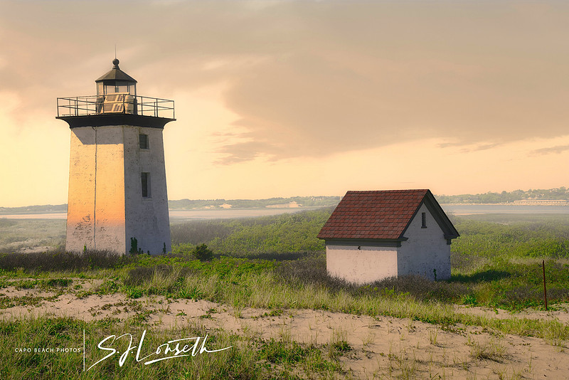
Wood End Light 0n The Spit - The sandy spit at Provincetown Massachusetts has been described as a loose right handed fist shape. It protects the harbor from the larger Cape Cod Bay and the Atlantic Ocean. Navigation around the spit can be treacherous and deadly. So it was proved on November 10, 1871 with the sinking of the oyster schooner William H. Atwood when 6 crew members lost their lives due to the hurricane force winds that tore their ship apart onto the spit. Towns people were helpless to save any of them. No bodies were ever recovered. Some historians arguably call that year the worst maritime disaster year on record for Cape Cod. But 1927 also claims to hold a similar distinction with the collision of the Navy Submarine S-4 with 42 men aboard and the Coast Guard Cutter Paulding. All the submarines' crew were lost, trapped when it sank in 110 feet of water. It took 18 days to recover the vessel due to high winds and icy conditions.There have been over 50 shipwrecks in the Cape Cod area since 1875. Race Point Light, further south on the spit was first built in 1816 and Long Point at the northern tip of the spit in 1927, but each had gotten subsequent rebuilds and upgrades. Wood End had been a lookout station at its current location by 1864, but the nearest access for help was walking 6 miles to Race Point Light in soft, difficult walking sand. The present day stone causeway or breakwater connecting the spit to town was not built until 1911. Even so, that was one mile long and only accessible at low tide. The U.S. Congress was convinced that more advanced maritime aids were needed after the 1871 wreck of the Atwood schooner and appropriated funds of $15,000 to build the Wood End Light tower and so it was constructed in 1872. In the lantern room was a fifth order Fresnel lens on a 39 foot high square pyramidal brick tower originally painted brown. The light could be seen 13 miles out to sea on a clear day. It was not until this location became a full multi-manned life-saving station, storage shed, oil house and 2-story light keeper's wood framed house in 1896 that it became fully functional to perform life saving rescues. The first light keeper at Wood End Light was a Massachusetts retired civil war decorated Quartermaster sergeant by the name of Thomas Lowe. After finishing his war service in 1865, he was hired by the U.S. Lighthouse Board and stationed at Highland Lighthouse also on Cape Cod. He rose through the ranks to become head Lightkeeper but remained at Highland until he was transferred to Wood End in 1872 when it was built. He served for 25 years until his retirement in 1897 and was responsible for saving many mariners' lives. He would on occasion have to depend on help from the town folk to help assist in a sea rescue but his faithfulness as head Lightkeeper was unwavering and appropriately recognized by the Lighthouse Board with multiple awards and metals of heroism . A true American hero. Wood End Light was fully automated in 1961 and became the first Massachusetts lighthouse to be totally solar powered in 1981. It remains an active aid to navigation guiding mariners safely into Provincetown Harbor. Personal Side Note for reference: If you venture this walk across the breakwater yourself, you need to be aware of a few tips. . . I started the one mile long trek across the stone breakwater from the mainland at around 2:00pm on a Tuesday afternoon in order to take the photograph you see in this blog. High tide I knew was at around 5:30pm. The breakwater took me 45 minutes to walk with no stops. Now that may seem like a lot of time for a one mile walk ( and I took no breaks), but the stones have large gaps between, gaps that require some jumping. Good shoes with traction are a must. (This alone should deter a short-legged person I think, such as my wife at 5'-2" height, i.e. she decided not to venture out which was a good thing). Then another 45 minutes out on the beach through loose dry sand to get to the Wood End Light. After about 20 minutes walking around the Light, taking photos, resting for ten minutes, I was ready to walk back again. There are no water sources and no restrooms. I was about 3/4 the way back on the breakwater when I realized I was very close to not finishing the trek due to the high tide. Several low areas on the breakwater were now underwater and seaweed covered, i.e slippery. These were stones I now needed to step onto in order to make it over those high water covered low areas. I felt quite tenuous about it. Beware if you venture out over this breakwater. Timing is everything. It is doable, but requires close attention to tides and caution over those larger rock gaps. Not for the faint of heart. . . . Pemaquid Reflections-Revisited
What do the native American Abanakis, the Vikings, shipwrecks, the War of 1812, ghostly images of a bride-to-be and the Maine quarter all have in common ? The Pemaquid Neck and the Pemaquid Lighthouse that's what. Maine's most famous lighthouse marks the west entrance to Muscongus Bay in from the Atlantic, near the town of Bristol. This lighthouse is considered the flagship of the 60 currently active in the State. In 2003, Maine citizens voted to have Pemaquid Lighthouse represent the State on the backside of their quarter. The cliffs in front of the lighthouse from the ocean side are geologically unique and are well weathered from centuries of storm exposure. High tidepools offer plenty of opportunity for lighthouse reflections as you can see ! Pun intended . . . The word Pemaquid means "situated far out" in the Abanaki native language. While some historical records show excavated evidence (in the form of coins and jewelry) of Viking settlements as early as 1000 A.D. (authenticated by carbon dating), at this location and others such as northern parts of Newfoundland, Canada. Most authenicated historical accounts show Pemaquid to have had flourishing trade and fishing industries in the New World long before the Pilgrims landed at Plymouth in 1620. The Icelandic Sagas also reflect the cultural and history of known Viking encounters and established settlements both in Greenland and in the New World as early as 950 AD. The Sagas as they are referred to, included poetry and literary writings with passed down heritage about this time period. History has recorded that the Vikings as a culture were relentless explorers with skilled navigational prowess. Many shipwrecks have occurred at Pemaquid Point over the years, before and after the lighthouse was built. The first recorded shipwreck off Pemaquid Point was that of the 240-ton English galleon "Angel Gabriel" in 1635. Having sailed from Bristol England with passengers, crew, supplies and livestock for the New World settlements, it took two months for the ship to reach the Maine coast. While most of the crew were ashore during the first night for much deserved shore leave, the Great Colonial Hurricane of 1635 hit the area and the ship was dashed against the rocks. All cattle and horses were lost. Only two of the remaining crew aboard made it safely to land. There was one crew member whose journey on the ship was to be his last before returning to Maine and his bride-to-be. It is said her ghost haunts the lighthouse even today, while she awaits her financee to reach shore after the sinking. Visitors have reported seeing a momentary glimpse of a shadowy female form dressed in a white gown. Lights have turned on and off mysteriously in the tower at all hours of the night with no one present. Even after the lighthouse was built there were devastating shipwrecks including the Edmunds (1903), Annie Collins (1891), Alice Higgins (1893), the Sadie / Lillie (1903) and the Willis Guy (1917). In 1813, during the War of 1812, the U.S. sailing warship Brig. "Enterprise" fought it out with the English warship "Boxer". Neither ship sank but both were heavily damaged with casualties on both vessels including both captains, all witnessed by Bristol inhabitants from shore. Originally commissioned by our sixth U.S. President John Quincy Adams for $4,000, the Pemaquid Light started off atop the keeper's dwelling in 1827, at the SE point of the Pemaquid Neck (Maine term meaning a long finger of land). It had to be reconstructed as a new 30 foot whitewashed conical rubblestone tower in 1835 where it presently sits, overall some 79 feet above the water below. The original stone masons in 1827 used salt water as a mix with the lime mortar which caused the demise of the original structure. Extensively repaired again in 1857 after storms and exposure to the elements, its ten-sided iron lantern room was fitted with a 4th order Fresnel Lens and a new one and a half story keeper's dwelling. The original Fresnel lens still operates today and allows the beam of light to be seen some 14 miles out to sea. A fog-bell brick structure was added a few years later (seen in red brick in the photo above) and the bell had to be hand operated until an adjacent weight tower was added years later so the bell could activate mechanically. In 1934, Pemaquid became Maine's first automated sentinel of the night along the Maine's rugged coastline. The fog-bell brick structure and weight tower had to be reconstructed after they were destroyed by hurricane Bob in 1991. The most dangerous part of taking this photo was keeping an eye on the crashing waves behind me. It was a fairly calm day on the water as I was standing about ten feet from the water line but swell after swell threatened from behind. Photo was taken late in the afternoon with a Nikon D800, 24-70mm zoom lens set to 32mm, f/14 at 1/60s, matrix focusing at ISO 100. This photo is perhaps one of my most favorite of the that trip to Maine.
Cape Florida Lighthouse-The Dead Man Beside Me
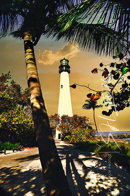
The Dead Man Beside Me The history of the Cape Florida Lighthouse is 200 years long and protracted with such events as construction fraud, destructive hurricanes, beach erosion that threatened the tower's stability, death, struggles for survival, violent attacks by indigenous people, fires, oil lamp explosions, civil war vandalism, then reconstruction. This short blog will recap but a few events in its colorful history. Stay tuned for the Rest of the Story in a future blog. . . In the early 1820's, a parcel of three acres of land on Key Biscayne was sold by the Waters Davis family to the federal government. Keep in mind it was only in 1821 that the US government took control of southern Florida from Spain. Spanish Explorer Juan Ponce De León had named the southern tip of Florida as Cape of Florida in 1513. Soon after being awarded the contract to construct the first lighthouse in southern Florida on Key Biscayne, as well as one in Key West and Dry Tortugas, Samuel Lincoln set sail from Boston to Florida in August of 1824 with plans and construction materials on board. He and his crew never arrived and were never heard from again. Assumed lost at sea, he was replaced by Noah Humphreys to build the lighthouse at Key Biscayne. The original 65 foot brick tower built with a concrete base set on a coral reef had an internal wooden staircase, and was completed by the end of 1825. ( It was later determined that the contractor had defrauded the government by making the upper brick walls of the tower hollow so as to save the cost of brick and to make the schedule.) The area of land where the lighthouse was being built was a vital sailing off point for black Seminoles escaping slavery to freedom in the Bahamas where slavery had been outlawed. Known as the Saltwater Railroad, the building of the lighthouse and the bustling activity in Key Biscayne hindered this escape route. After being appointed as the first lighthouse keeper, Captain John Dubose, found it necessary, after a few years, to move his wife, 5 children and two former African-American slaves to safer surroundings in Key Biscayne, just north of the lighthouse. However it soon became apparent to him, this was not far enough away from the local Seminole tribes that were growing increasingly hostile. He then moved them to Key West. Hostilities grew even bolder by 1830 when, the Bureau of Indian Affairs, formed in 1824, tried enforcing the Removal Act passed by Congress. By coercing the Seminole nation to relocate to the Indian Territory, established in what today is known as Oklahoma, they outraged them even further and began the Second Seminole War. Subsequently, on July 23, 1836 a band of Seminoles attacked the lighthouse compound in their growing hostility to the US government. With his clothes now on fire, Thompson, stood up to the railing and was considering jumping to his death after recommending his soul to God as he later stated. But rather, he managed to hurl the remaining gun powder keg down to the bottom of the fully inflamed wooden staircase hoping to end his misery by toppling the entire tower in an explosion. The result however was that only the staircase collapsed and the fire extinguished. The explosion and resulting pillar of fire was seen by the U.S. Naval schooner Motto, some 12 miles away. By morning, when they reached the Lighthouse, the seamen from the ship found Thompson barely alive at the top of the tower, and the attackers temporarily gone. Thompson was unable to get down due to the staircase's destruction and his serious injuries. With a series of ropes and pulleys, and some ingenuity, two naval seamen from the Motto were able to reach the top of the tower and rescue Thompson. Thompson was sent to a military hospital in Key West and later to Charleston, South Carolina to recover. Though severely handicapped by his injuries for the remainder of his life, he continued to live out his days. In light of the ongoing hostilities with the native Seminole nation, the island of Key Biscayne was uninhabitable for settlers and the lighthouse lantern went dark from 1836 until 1846. But in 1847. . . .
Cockspur Island Lighthouse - In The Line of Fire
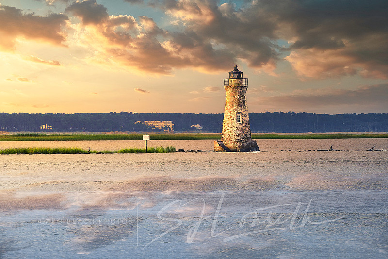
Cockspur Island Lighthouse - In The Line of Fire Fort Pulaski on Cockspur Island, Georgia (to the left side and out of view in this photo) was fully occupied as a Confederate fort with a garrison of about 361 men at the beginning of the Civil War. But the Union wanted to end the choke hold that allowed the South to protect the port of Savannah. On April 10, 1862, Union forces began firing varying sized rifled artillery rounds from 11 artillery batteries equipped with 36 of the newly invented “Parrott” rifled cast iron cannons. Artillery batteries were stretched out along the north beachhead of Tybee Island across the Savannah River. The furthest east battery positions on the beach were still able to reach the walls of the Fort with shells despite being some 3400 yards away. This was entirely possible only because of newly invented precision military technology of the rifled cannon. Closer batteries, with smaller sized ammunitions, were located less than 1600 yards away from the walls of the Fort. After 30 hours of relentless precision bombardment, the Confederate forces surrendered Fort Pulaski. The Fort had been built between 1829 and 1847 with roughly 25 million bricks, 7.5 ft thick walls, 25 feet high, and built by enslaved peoples rented from nearby plantations. It was one of over 42 coastal “Third System” fortifications built by the Federal government after the War of 1812. Once thought invincible to standard cannon ball munitions, the new technology of rifled cannons made the U.S. coastal forts very vulnerable. The Cockspur Island Light located at the SE tip of Cockspur Island was only accessible by boat or by foot at extreme low tide and was directly in the line of the artillery shelling by 3 batteries easterly positioned on the Tybee Island beach. The Light had been extinguished at the beginning of the Civil War so as to not aid Union naval blockades or assaults. The tower was not the military objective of the Union attacks on the Fort but stood in the direct line of fire of those 3 battery positions. In order to be an effective bombardment on the Fort, the Union’s "Parrott" rifled artillery rounds and percussion shells were hurled in such a trajectory over the brick Lighthouse Tower that it suffered no significant damage. Courtesy of Google and American Battlefield Trust here is a Link to the Union Pre-Attack Strategy Map: https://images.app.goo.gl/Vm9f1qZviuYBWfu8A
By August 1958 President Eisenhower signed into a proclamation a transfer of ownership of the Cockspur Island Light from the US Coast Guard to the National Park Service. Preservation of this Light Tower, Georgia’s smallest, is ongoing. In 2007, the Light was relit for historic recognition.
BHL-Nuclear Light
America's Only Nuclear Powered Lighthouse- Originally funded in 1894, construction was not completed until 1907 and finally lit in 1908. It is located on Chesapeake Bay, as the last lighthouse built on the Bay it marks the entrance to the Craighill Channel near the mouth of the Magothy River leading to Baltimore Harbor. Construction difficulties included flooding and subsequent sinking of the caisson, re-erecting the caisson and fierce winter storms delayed the completion for almost 18 years. As it turns out, the BHL (Baltimore Harbor Light), as it was known, became one of the most difficult lighthouse construction projects ever built in the United States. Above the waterline it stood 53 feet and some 88 feet below the mean water line, resting on 91 pilings driven into the muddy bottom of the Chesapeake Bay. It was a partially filled with concrete, steel caisson foundation with a 30 foot diameter building platform, painted white brick octagonal two story super structure measuring 24 feet in width, mansard shaped slate tile roof and with a black lantern enclosure to top it off. The original caisson engineering criteria was that it needed to resist 100mph winds, 30,000 pounds of ice pressure per square foot and almost constant 3 mph underwater currents. In 1964, the U.S. Coast Guard buoy tender White Pine installed a 60-watt nuclear isotopic power generator about the size of a 55 gallon drum weighing 4600 pounds, as an experiment to see if such a power source could be used in remote areas for sustainable long term power. The BHL was America's only, and the world's first, nuclear powered lighthouse. After two years, the nuclear powered generator was removed having proved itself worthy. As a side note, while the generator was being installed, the lighthouse was passed by the world's first nuclear powered cargo-passenger ship, the historic NS Savannah, now currently moored at the Port of Baltimore, Maryland. The lighthouse lantern is currently solar powered and still maintained by the U.S. Coast Guard; the lighthouse is fully restored and privately owned. Photo taken in September 2023 from the shoreline along Shipsview Road near Cape St. Claire, Maryland using a Nikon D850 DSLR, Nikkor 500mm lens (hand-held), manual exposure setting f/14, shutter speed 1/250, ISO 125.
Standby To Standby
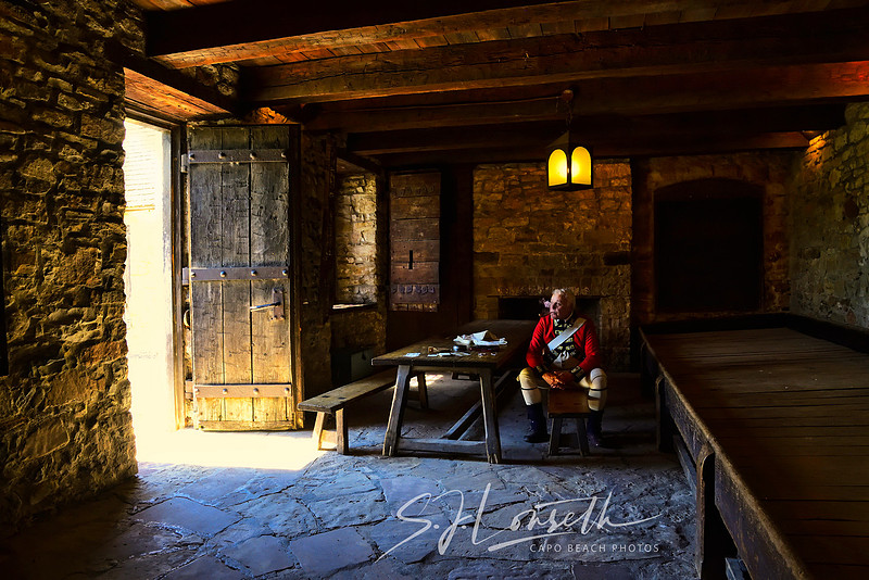
Standby To Standby - Harsh winters, starvation, scurvy, drunkenness, disease as well as attacks by native Americans and foreign armies plagued Fort Niagara at one time or another over its' 300 year history. In the late 1600's the French were especially hard hit by starvation and disease. In 1687 while it was named Fort Denonville, 100 French soldiers were left to winter here, only 12 survived. Of particular concern for British command in the years between 1759 and 1796 was boredom among the rank and file. British red-coat soldiers, also known as "lobsters" and "bloody backs" (as labelled by colonists) were stationed here to secure the entrance to the Niagara River which led to the Great Lakes and to carry out raids on American colonists. Yet in standby preparation, the garrison of British soldiers stationed at Fort Niagara's 1726 era French-built Castle "mansion" were required to be always ready in full uniform. I photographed this British Red Coat re-enactor while visiting Fort Niagara in July 2021. In my brief interview with him, he was stoic and a man of few words. He did convey his role as an era-correct contingent of the garrison. Here was a non-commissioned British regimental soldier, a private or corporal at best and as he put it. . . plagued with extreme boredom. He was enacting smoking a tobacco pipe as so many did and portraying playing cards on the table as a relief for the boredom. Despite being well disciplined troops, this boredom often led to gambling with cards, drunkenness and brawling, all strictly against British military regulations for a British soldier but they did so nonetheless, he stated. A British soldier was rationed roughly five pints of small beer per diem (usually diluted to avoid excessive drunkenness). Winter boredom would have consisted of much the same, more or less, but with the added difficulty of staying warm in subzero temperatures even while inside. In the French Castle, fireplaces were common in every room to avoid freezing. Supplies would come from England every two months or so but at other times not at all. These soldiers also faced disease and scurvy under harsh winter conditions. Some were married with wives housed at the fort as well. Marriage was greatly discouraged by Commanding Officers. Fort Niagara in western New York has a long history as a conflicted military stronghold. It was a strategic location for controlling all maritime traffic entry from the Atlantic Ocean into the Great Lakes. The first military settlement at Fort Niagara located at the mouth of the Niagara River off Lake Ontario was established by the French as Fort Conti in 1679. The trading post and military fortification protected their fur trading interests with the indigenous people and their continuing exploration and settlements around the Great Lakes. The indigenous peoples of the Iroquois Confederacy included originally Five Nations: the Mohawks, Oneida, Onondaga, Cayugas, Senecas and later in 1722 the Tuscarora peoples to make it Six Nations. To protect their affairs, the French strived to form an alliance with the Six Nations for the purpose of defeating any invading forces namely the British. However the alliance with the Iroquois tribes especially were strained at best. In 1726 the French were allowed by the Iroquois Confederacy to build what they called a "House of Peace", yet built of stone. The French conned the Confederacy and built the French Castle at Fort Niagara in the form of a french styled mansion so as to minimize the appearance as an armed fortification. But the building housed garrisoned military personnel and munitions storage. See the following link to other Fort Niagara photos taken by myself on this same tour in July 2021. In those photos you will see the stone Castle, the reinforced stone Redoubts used for perimeter protection as well as the bermed fortifications with artillery batteries. The French continued to fortify and strengthen the Fort during the King George's War of 1744-1748 and during the French and Indian War beginning in 1754 through 1757 by building massive earthen berms, structures for provisions and munitions storage. Then in 1759, besieged by night and day bombings, an overwhelming British force and tunneled intrusions, the French held Fort succumbed to a 19 day siege by British forces. In 1770-1771 the British built two stone Redoubts to shore up their perimeter defenses around the Fort. The British held control of the Fort throughout the American War for Independence and used it as a base for raids against American colonists and as a refuge for Native allies, the Tories and British loyalists in the colonies. However in 1796 Britain was forced under treaty to turn over the Fort to the Americans. During the War of 1812, Fort Niagara was again captured by British troops as a stronghold. They again forfeited control back to the Americans by treaty in 1815. By 1825, the building of the Erie Canal greatly diminished the strategic importance of Fort Niagara. The Fort has been used for U.S. troop training and staging for the Union during the Civil War, troop readiness for the Battle of Manila in 1899 in the Philippines, and for WWI and WWII. In 1944 it was used as a prisoner of war camp for German and Austrian POW's. Today the Fort welcomes some 200,000 tourists annually. Since this photo was taken in very dark interior conditions, camera settings were adjusted accordingly: ISO 1600; aperture f/8; shutter speed was reduced to 1/20 using a Nikon D850 with a 28mm lens but hand held.
|