|
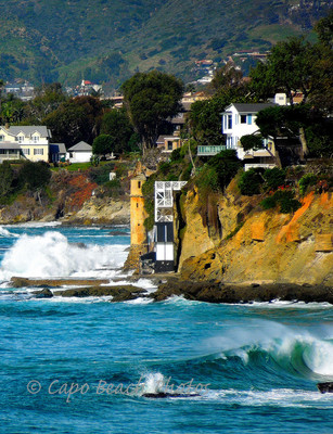
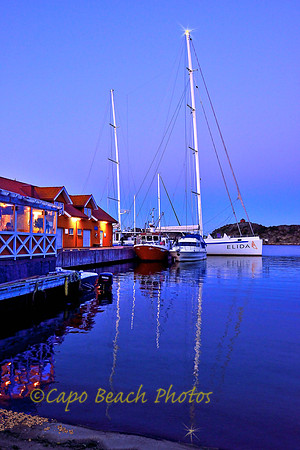
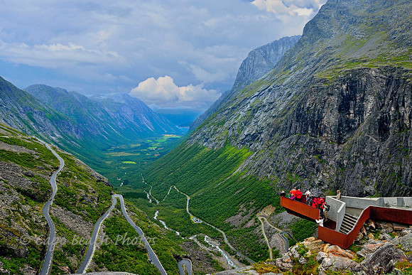
Bloggin' the Whole Story Thanks to everyone who frequents this website for the photos and blogs. On this blog site there will be a variety of photos and descriptive posts. Some posts involve extensive research, both from talking to locales and supplemented from the internet, while others are posted for the simple photo alone. Please enjoy and don't be afraid to give back your comments, good or bad. La Tour - Victoria Beach TowerVictoria Beach Tower The La Tour Tower in Laguna Beach is the most public thing on an otherwise fairly- private public beach. The beach is accessible by a long narrow meandering staircase squeezed tightly between affluent cliff-perched homes. It was originally built in 1926 by California State Senator William E. Brown. The tower was a way for the Senator and his wife to access the beach from high atop the embankment of their summer house. This was their summer place because Mrs. Brown despised the "blistering" heat of their Beverly Hills home during the summer months. Despite the house having changed hands several times over the years including once having been owned by Bette Midler and her husband, the tower remains pretty much the way it was built despite the battering from the Pacific Ocean surf and salt air. It is made of poured-in-place reinforced concrete, coated with cement plaster, a rubble ocean-stone concrete base, a conical shaped shingled roof with an internal metal frame and wood spiral staircase. In February 2012, the City of Laguna Beach condemned the tower from further human use due to its faltering condition. It still remains for photographers such as myself and for the late evening romantics who enjoy the beach at sunset. Elida VElida V This 131 foot, 95 ton sailing vessel is a performance yacht and a passenger boat built in composite and completed in 2007 after five years of construction. It is sponsored by a Swedish Christian organization whose crew is made up almost entirely of Christian youth. Over 1,000 teenagers rotate during the sailing season to crew on the boat. The yacht sails along the southern coasts of Sweden, Norway in the spring and summer months for the sole purpose of spreading the gospel of Jesus Christ through music and personal testimonies of its crew. During the winter months the boat sails the southern European coastlines. The yacht's motto, painted in large letters on the sails is "Sailing for Jesus" and proclaims no afffiliation to any one denomination nor organization. It is also affectionately known as the "sailing singing church". This photo was taken in Stavern, Norway along the sunny southern coast in July of 2013. My wife Elizabeth and I stood on the pier where the boat was docked one balmy summer's evening and listened to the singing by the teenage crew. Birdmen of TrollstigenFlying Birdmen of Trollstigen On October 11, 2009 CBS News 60 Minutes aired a TV segment about extreme sport athletes who put on "squirrel suits" only to jump off ultra high mountain tops with only one parachute. A portion of that segment was filmed in the Isterdalen valley with these very same rock cliffs. See this link for the flight: http://www.cbsnews.com/news/taking-flight-with-the-birdmen-09-10-2009/ These "Birdmen" fly at speeds up to 150 MPH coming dangerously close to the shear rock on their way to the bottom. Trollstigen pass (meaning Troll's Path) rises to an elevation of 2780 feet (850m). The cantilevered outlook viewpoint shown here is only at 2300 feet. The surrounding mountain tops (out of view) have such names as The King, The Queen, and The Bishop. The King, or Kongen in Norwegian, rises to an elevation of 5295 feet (1614m). The road up to Trollstigen has a 10% incline and has 11 hairpin turns. The road began construction in 1928 and opened in 1936. For many years the road was only wide enough for one car and turnouts were far and few between. Such was the road when I first traveled it with my Norwegian grandparents in 1958. The turns were so tight that even small tour buses needed to make several back and forth maneuvers at each hairpin. In 2005, the road was improved so two lanes were the norm and tour buses could negotiate the turns in one attempt. During the summer season, about 2500 vehicles per day use Trollstigen pass with a total of 162,000 vehicles in 2012. This photo was taken on a rainy day in August of 2013. Pulpit Rock
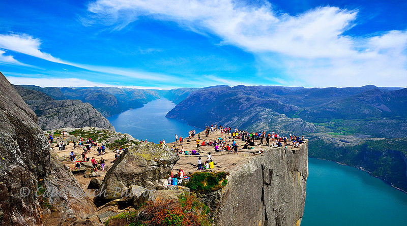
About 20 miles east of Stavanger lies one of Norway's most popular tourist attractions, 'The Pulpit Rock' or Preikestolen in Norwegian. Perched some 1982 feet above Lysefjorden below, this 82 feet x 82 feet semi-flat hunk of granite tabletop rock sits precariously out over the water. In 2012, some 200,000 tourists visited this attraction. In the summer of 2013, my wife and I ventured up to "peek" out over the edge. I can tell you it is straight down to the water, no safety ledges, flat meadows or tree branches protruding out to cushion someone's fall. It took us about 2 hours to hike up to this spot seen in the photo. No switchbacks. In some places along the trail there were wood planked bridges suspended out over deep crevasses with nothing below but rock and water. The climb is so steep at several locations, they have huge stones placed like a staircase to ascend the height. Stones with heights of two feet and higher. I am 6'4" tall and have fairly long legs but in places it was all I could do to negotiate from one step to the next with no railings or cables to grab onto or hold. This attraction defies every health and safety code known to man but draws thousands of tourists every year nonetheless. The trail towards the top can be as narrow as 3 feet (with people passing in both directions) and once to the top, you must be extremely mindful of the edge since it has no railings (not even cables), no warnings signs, no fences. Just a rock edge that ends and plummets 1900 feet. Both my wife and I ventured out to the edge to get a glimpse downward. . .on our stomachs. Quite impressive view, well worth the climb. Though I do not have a fear of heights (in most cases), I definitely feel that heights like this warrant utmost respect. Tourists at the top were sunbathing, conversing, taking photos, drinking water, eating snacks and dangling their feet over the edge. Even saw one woman sketching the scenery on a notepad while dangling her feet over the edge. One older gentleman told us he owned a farm on the plateau off in the distance, and in all his years on that farm had never climbed here to the top. "Had to do it at least once", he said. The view and size of this landscape would make any human being truly feel insignificant scale-wise. God's creation is simply astonishing. There had not been any deaths from The Pulpit Rock for over 50 years. But in October 2013, just 2 months after we visited, a young Spanish tourist went to the edge to take one last photo, lost his footing, and fell to his death. It was reported his friends said one minute he was there, the next he was gone. Follow-up: the folklore story to tell is of Odin, a folk god of the old Viking era in Norway. Odin is said to have overseen his kingdom in Norway and all the countryside from this pulpit rock. If you have seen the last episode of The Vikings for season 2, you would have noticed the last scene of the season with Ragnar in the distance on the Pulpit Rock, crouched down, and clutching King Horik's Sword of the Kings. Living by the Sea
Living By The Sea An ideal setting for reading a long-winded novel or just escaping with your thoughts don't you think ? These were my first impressions of this quintessential get away by the sea, the Norwegian Sea to be exact. This summer cabin by the sea was spotted while en route back by ferry to the mainland of Norway from Ona Island (previous post Ona Island Lighthouse and Ona Cannery). What struck me about this structure was how stout it appeared, built of a stone foundation with concrete, cement block and a tile roof. It would have to be sturdy to withstand the horrific storms coming in from the Atlantic Ocean during the winter months. Yet here in August of 2013, it looks overly obtrusive in the peaceful seacape. Secondly, it is built on what barely amounts to a slight rise above water level, granite rock with some shrubs and sea kelp. You can not see the entire "island" in this photo but it only extends for another few hundred meters to the right of the photo. The portion to the right is the highest point of the island. It is estimated that over 83 % of Norway either owns or has direct access to a summer or winter cabin. . .that's a lot of cabins. The word for cabin in nynorsk Norwegian is "hytte". The typical Norwegian is of hardy stock and independent as all get out and you would have to be to remain here all winter. However, during the summer months, they take to water like ducks to a pond, with boats of all types such as kayaks, dories and rafts as seen in this photo. I counted at least 4 kayaks, one dory and a rubber raft next to this cabin by the sea. The flying pennant is called a "vimpel" and almost always indicates someone is home. A vimpel always has the national colors and can be flown all hours of the day unlike the national flag itself. Norwegians are very patriotic and it has been surveyed in Norway that less than 6% of the population do not own a flag of some type, even vimpels. Eigerøy FyrEigerøy Fyr ( Lighthouse ) - The word for lighthouse in Norwegian is "fyr". So in keeping with my norwegian heritage, I am using that word in this post. This particular fyr located on the island of Midtbrød is also cast iron as was the Ona Island Lighthouse in the previous post. Some 12 km southwest out towards the Atlantic coast from the town of Egersund, it is about a 30 minute walk along a pedestrian path called Fyrvegen ( the lighthouse road ), and is cordoned off with wood railed gates at several points to keep local farm animals such as sheep, goats and cows from escaping. The conical cast iron fyr was first built in 1854 and was Norway's first made of cast iron. Many others followed, up and down the coast of Norway. There have been 212 lighthouses in Norway with only about 154 ever being operational at the same time. The first lighthouse was at Lindesnes in 1655. Current navigational aids along the coast of Norway number around 5,052 spanning from Sweden on the south coast to the border with Russia in the northeast. These are unmanned but automated and many are only light beacons. The first order Fresnel lens used here at Eigerøy is Europe's strongest lit, burning some 3.95 million candelas strong and shining out into the Atlantic 18.8 nautical miles. Automated in 1989, it stands 108 feet tall (33 meters). During WWII there was a German outpost just out of camera view to the right in this photo. Its concrete shell remnant still remains. We arrived here very late in the afternoon. So late in fact that the dragonfly- sized mosquitoes were out in full force. If not for wearing long sleeve shirts and hats, they would have eaten us alive. As it was, we did not stay long and kept moving only stopping long enough to set up the photo shoot and drink some water. |