|
Bloggin' the Whole Story Thanks to everyone who frequents this website for the photos and blogs. On this blog site there will be a variety of photos and descriptive posts. Some posts involve extensive research, both from talking to locales and supplemented from the internet, while others are posted for the simple photo alone. Please enjoy and don't be afraid to give back your comments, good or bad. Abandoned and Abused It Stands
The Abandoned Bandon Lighthouse -Abuse is the first word that comes to mind looking at the Coquille River Lighthouse. Originally known as the Bandon Light and completed in 1896 with $50,000 in congressional appropriated funds, it has taken abuse from the weather - rain, snow, wind and the damaging sea salt air of the Pacific Ocean. It has withstood the abuse by vandals and just plain neglect by human hands. Abandoned as unsalvageable in 1939 because on a new automated beacon on the south jetty to the river, it still persists and refuses to go away, standing valiantly as guard over the entry to the Coquille River in Bandon Oregon. Though renovated in 1976 you would hardly know it looking at it today. When built it was desperately needed to help guide large ships past the treacherous sand bars at the mouth of the Coquille River. Ships were there to load prime timber from Oregon's forestlands. Built in the High Victorian Italiante style of architecture, octagonal in shape with a conical 40 foot high tower, it was originally equipped with a fourth-order Fresnel lens and a huge trumpet in the tower facing west, toward the Pacific, that blared out warning signals to approaching ships. The schooners Moro in 1896 and the Advance in 1897 both ran aground on the north jetty despite the lighthouse. It was reported by each captain that the trumpet sound confused them in navigating the river entrance. The trumpet was later replaced by a fog horn signal because the trumpet sound even irritated the town folk. The town of Bandon was founded in 1873 by an Irish immigrant Lord George Bennett, who named the town after his hometown in Ireland. While establishing his newly founded town he introduced a plant indigenous to Ireland known as Gorse, also commonly referred to as Scotch Broom. This plant is especially oily and easily fuels the spread of fire. In the late summer of 1936, a small patch of gorse caught fire several miles east of town and was spreading eastward away from town when the wind suddenly shifted. Within six short hours the entire town was engulfed in flames shooting 100 feet into the air. Scotch Broom had been planted everywhere in town, in between buildings and in front yards as well as backyards. Virtually the entire town burned to the ground that day including the log piled piers where ships were loading logs. Burning through acres of Scotch Broom, the fire was unstoppable said one town firefighter. "Dousing the flames with water was like pouring gasoline on the fire", he said. Ten town residents perished during the fire that day. Hundreds of people had gathered on the south jetty during the fire so as to be ferried over to the north side of the river where the lighthouse stood. The Bandon Lighthouse constructed of concrete, stone and stucco was a safe haven from the fire. It provided the town folk shelter in time of need. As you can see in this photo, Scotch Broom is still a common plant in and around Bandon. Little Redfish Creek Bridge
Located just off Redfish Lake Main Road near Stanley Idaho and constructed in early 2012 as a reroute of an existing trail head, this glu-lam wooden beam structure spans over Little Redfish Creek just below Little Redfish Lake. Being in the Sawtooth National Forest, construction was overseen by the USDA Forest Service, yet constructed by a private firm. Depending on the time of year, one can see Sockeye Salmon from this bridge returning upstream to spawn. Sockeye, also known as red salmon and blueback, have a vibrantly red color especially in spawning season. Redfish Lake gets its name from these red-colored sockeye salmon. Some sockeye have traveled 900 miles to return to spawn at this location, the farthest inland destination for red salmon in the U.S.. The sockeye Salmon population was terrible in the 1980's and into the early 1990's due to overfishing and environmental impacts, so much so that only one lone fish was counted in 1996 and that one fish became a legend known as Lonesome Larry. A local salmon hatchery along with other efforts have been instrumental in returning the salmon population. Efforts to regain the salmon population have resulted in thousands returning to Redfish Lake in 2010. The Sawtooth Mountains have been home to large glaciers in the past, some as recent as 1850. There are 57 mountain peaks over 10,000 foot elevation in this wilderness area, the highest of which are Thompson Peak at 10,751 feet and Mount Cramer at 10,716 feet. There are over 350 miles of wilderness trails throughout the Sawtooth National Wilderness Area. This bridge is the trailhead to about 12 high-elevation trails. In 1983 there was an earthquake in the Sawtooth Mountain range that registered 6.9 on the Richter scale. Known as the Borah Earthquake, it sent huge house-size boulders into southern Redfish Lake that can still be seen at the lake bottom. In 2010, a 40 mile long easterly lying fault line was discovered running through Stanley Idaho and Redfish Lake. Scientists say this fault line is capable of producing a 7.5 magnitude earthquake. This photo is one of my most favorite. There is a rich natural magic here: the serenity of the total scenery showing the luscious greens, healthy pine trees standing tall with red-brown bark, a new seedling merging from the marshy creek bed, a fallen tree trunk lying in the creek with the weathered wood colors of the glu-lam beam bridge structure crossing over a deep-blue, slow moving creek full of salmon. Photo was taken in May 2013 with a full-frame Nikon D800 using a tripod, with 28-300mm telephoto at 28mm, f/13 at 1/50s exposure, matrix focusing, ISO 250.
Surfin' USA
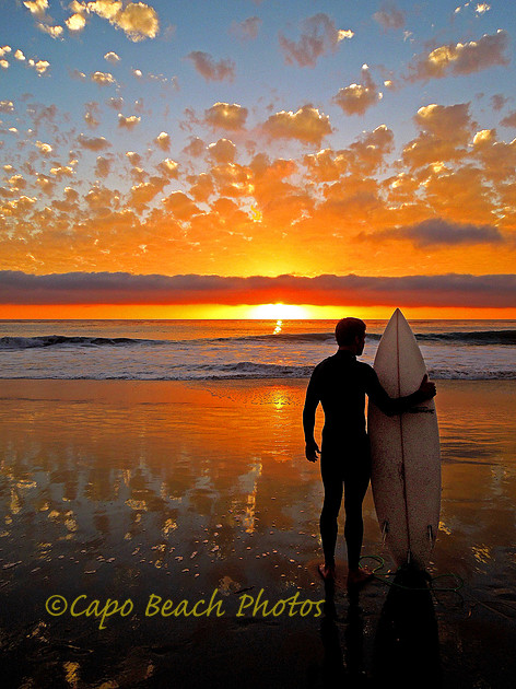
In March of 1963 the Beach Boys summertime hit "Surfin' USA" debuted and became # 2 on the Billboard Charts for that year. Brian Wilson of The Beach Boys had composed the lyrics set to the Chuck Berry song "Sweet Little Sixteen". This may have been a result of his brother Dennis Wilson, founding drummer of The Beach Boys, suggesting to Brian and Mike Love in 1961 that surfing is becoming 'really big' and that they should write a song about it. Despite all of the surfing songs and mystique about those California girls, golden sand, beaches and ocean waves, Dennis was the only member of the original Beach Boys to regularly surf as part of his lifestyle. While at the beach in 1963 with his girlfriend's brother, Brian Wilson started humming to Berry's melody of Sweet Little 16 and thought what a kick it would be to compose lyrics that included some of the major southern California top surfing spots as his brother Dennis had suggested a couple of years earlier. He asked his girlfriend's brother Jimmy, to give him a list of some of those hot spots which turned out to be Del Mar, La Jolla and Trestles in San Diego County along with Doheny and Sunset beaches in Orange County. Some other spots also got included like Waimea in Hawaii and Narrabeen in Australia. The Rock and Roll Hall of Fame lists "Surfin' USA" by The Beach Boys as one of the 500 most influential songs in rock and roll history. Whether you acknowledge the origin of surfing from the Samoan Islands, Peru or Hawaii, there is little doubt the sport has exploded into the modern day American sport scene. Whether you are a fan of "The Ambassador of Aloha" Duke Kahanamoku, Kelly Slater or Coco Ho, there is no doubt surfing has become and will remain for some time to come an integral part of the American lifestyle. While walking The Strand Beach at sunset one evening in 2013 near where I live in Orange County, the most amazing sunset was developing. The sunset in this photo is untouched. This was the sunset. The photo was taken with a Nikon S8200 with auto flash from about 20 feet back of the surfer. The surfer is unknown. The make of surfboard is unknown. What is known: God never fails to amaze with His Creation. The Lookout
Cape Blanco Lookout This is the view from the point at Cape Blanco Oregon looking south. It was named so by spanish explorer Martin de Aguilar in 1603 for the somewhat white cliffs. In the near distance is Needle Rock and in the far distance is Humbug Mountain. To the right (and out of this photo) are the Blanco reefs. This day was a mild blustery day. However, this headland is extremely windy during the winter months with speeds consistently registering 100+ mph. Behind me in this photo is the Cape Blanco Lighthouse currently maintained and operated by the U.S. Coast Guard. Coast Guard Station Port Orford is less than 6 miles away to the north, as the crow flies. Geologically, the area consists of marine sediment and the flat ground where I stood for this photo is about 250 feet above sea level. It is estimated by the US Geological Survey (USGS) that this headland is rising about 1" per year due to the ocean plates pressing under the coastline of Oregon. During WW II this headland point played a pivotal role in the only Japanese bombing of the U.S. mainland during the war. Seaman Second-Class Ezra Ross, from the Port Orford Coast Guard Station, happened to be here manning the lighthouse station when in the early morning daylight hours of September 9, 1942 he spotted a small two-seat reconnaissance float plane, known to the Allies as "Glen", launched from a surfaced Japanese Imperial Navy B1-Type class submarine. The submarine was the I-25, commissioned from Japan on 21 November 1941 and had participated in the bombing of Pearl Harbor on December 7, 1941. Here off the coast of Oregon, the float plane flew from the submarine with two incendiary bombs, and using the Cape Blanco Lightouse as a reference point, dropped these bombs on the forestlands of southern Oregon near Brookings in an attempt to start uncontrollable wild fires. Fortunately, it had been a very wet season with low winds and the fires were quickly brought under control. The attack was known as "The Lookout Air Raid". A U.S. Army A-29 Hudson had been dispatched from McChord near Tacoma, Washington with 300 pound general demolition bombs but was unsuccessful in destroying the submarine that day. The I-25 was sunk off the New Hebrides Islands on 25 August 1943 by the destroyer USS Patterson with its entire crew lost at sea. This photo was taken with a Nikon D800 with tripod, 26mm lens set at f/20 aperture and shutter speed 1/40s with +0.3EV exposure compensation, vivid color exposure setting, and ISO 125.
Montage Sunset
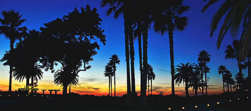
Located on 30 acres just south of downtown Laguna Beach, The Montage Beach Resort lies between the Pacific Coast Highway and the Pacific Ocean. With 250 luxury rooms and an exterior built in the Craftsman architectural style, the views of the ocean, especially at sunset, are suberb. Exotically landscaped walkways, make strolling the views over the Pacific inviting all year round. Light marine layers advancing in from the ocean can make sunsets colorful and unique. This sunset photo was taken over the resort's north lawn area looking west toward Catalina Island. The photo was taken about 15 minutes after sunset with a Nikon D7000, 10-24mm lens set at 14mm, f/9, 2 second exposure, no tripod (but resting the camera on a bench), no flash. Mountain BarnAlpine Mountain Barn - This mountain sheepherder's barn sits just off Highway 63 in central Norway. This highway is very popular with tourists in the summertime due to its access route to Trollstigen, and the "Trolls Ladder", a scenic mountain pass viewpoint overlooking the Isterdalen Valley. This is the location where CBS News 60 Minutes did a documentary several years ago featuring Birdmen who "flew" down mountain side cliffs while wearing flying squirrel suits. See the blog link from April 2014 for a video of these flying Birdmen. It should be pointed out that several of the Birdmen shown in that video have since perished in tragic "flying" accidents. http://www.capistranobeachphotography.com/blog/2014/4/birdmen-of-trollstigen These barns and other sheds are used by sheepherders during the summer months to store supplies and tools necessary for herding of their mountain flocks of sheep and goats. Flocks are led to the mountains to graze freely for the summer months. In the older traditional days of sheep herding there were many varying breeds of sheep. These breeds had learned to naturally protect themselves from predators by forming rings of protection, similar to what wagon trains used to do in the American west. Today, dogs are also used to herd the sheep to and from grazing pastures. These barns look very humbling when dwarfed by the Norwegian granite cliffs and mountains towering some 5000 feet above sea level. The rust stains of the metal roofs are a stark contrast to the lavishly green meadows, birch and aspens of these mountain pastures. Traditionally, foundations of these sheds were merely stacked stones gathered from where they could be found. Wood siding was usually rough sawn timber from local tree stands at lower elevations and left to weather. In the winter months, these sheds and barns are nearly covered in snow and ice. In this area of Highway 63, average snowfall amounts to about 5 meters or roughly 16 feet. |