|
Bloggin' the Whole Story Thanks to everyone who frequents this website for the photos and blogs. On this blog site there will be a variety of photos and descriptive posts. Some posts involve extensive research, both from talking to locales and supplemented from the internet, while others are posted for the simple photo alone. Please enjoy and don't be afraid to give back your comments, good or bad. Blue Sapphire
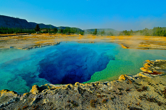
Reaching temperatures in excess of 202 degrees F, the Oriental Blue Sapphire Pool is part of the isolated thermal group known as Biscuit Basin, located in the larger Upper Geyser Basin of Yellowstone National Park in Wyoming. Biscuit-like sinter deposits prominently lined its crater edges in the 1880's. However, an earthquake in 1959 dislodged many of the knobby formations. After the earthquake many large eruptions occurred at two hour intervals and some reached as high as 150 feet. The eruptive forces caused the crater of the oriental blue sapphire pool to double in size but by 1968 the pool ceased to function as a true geyser. Today, the pool is about 18 ft. by 30 ft. and with an estimated depth of 125 feet. Occasional surges and violent boiling still occur but it remains quietly dormant the majority of time. These pool waters in Yellowstone will boil at around 198 degrees F. The crystal clear water and vividly blue color is true to life in this photo. The blue color is due to the sterile water purity from extreme temperature and the depth of the pool. Surrounding bacteria fields which often create rainbow-like colors are virtually non-existent here due to the temperature. Red HotRed Hot The Grand Prismatic Springs is the largest hot spring in the continental United States at 300 feet in diameter and 160 feet deep. It lies within the Midway Geyser Basin of Yellowstone National Park in Wyoming and with only an average temperature of 160 degrees it is not the hottest in Yellowstone National Park.
There have been an estimated 26 deaths since 1890 in Yellowstone directly related to geo-thermal areas, many more for other reasons. One of the saddest is the story of a 24 year-old California man who in 1981 dove head-first into the Celestine Pool's 202 degree water to rescue a friend's dog who became trapped in the pool of boiling water after falling off the adjacent wooden walkway. The man managed to swim back to the pool edge with the dog and when helped out by bystanders he was blind with third degree burns over his entire body as was the dog. The dog did not survive. He said to onlookers when he was helped out: "That was a very stupid thing I did but I had to try to help the dog." He died the next day in a Salt Lake City hospital. Vandalized
Dory Boat No. 56 For over 10 years the San Clemente city lifeguards had not competed in any surf boat rowing races. With grand hopes of competing again, they acquired one of their previous dory boats back from one of the veteran rowers who had been caring for it. Then just weeks before the competition in June 2011, the dory boat was vandalized and left in the shorebreak surf only to be beaten in half and covered in sand by the waves. It was history. Coastal lifeguards are a close-knit community of veterans and active lifeguards who take great pride in their competitive skills with these dory boats as rowers in heavy surf. San Clemente city lifeguards are no exception. With no money for a replacement dory boat, one was found and donations were sought for buying it. A second, 1980's era, surf boat was donated to them by the National Doryman's Association. The lifeguards spent hours of their own time restoring the boat for competition at the San Clemente Ocean Festival held annually in July. This is that boat. While even today still needing a complete restoration, it is competition worthy. Originally built by the Schock Boat Company in Newport Beach, it is shown here secured to the Marine Safety Headquarters building at the San Clemente State beach at sunset. The boat still shows reminders of its past life even through the new coat of epoxy paint with its new number - 56. In its past life, this dory boat was used for many years by the Bolsa Chica State Beach lifeguards until it outlived its usefulness for their competition. The new 'old' dory boat No. 56 has earned its second life in San Clemente. Old dory boats never really die, they just fade into the sunset . . . especially in San Clemente, California. Walking along the North Beach trail in San Clemente on a summer Sunday evening in 2013 provided the chance to take this photo with a Nikon S8200, set at 1/1600, f/3.3, auto flash, ISO 100. Cultural Monument No. 187
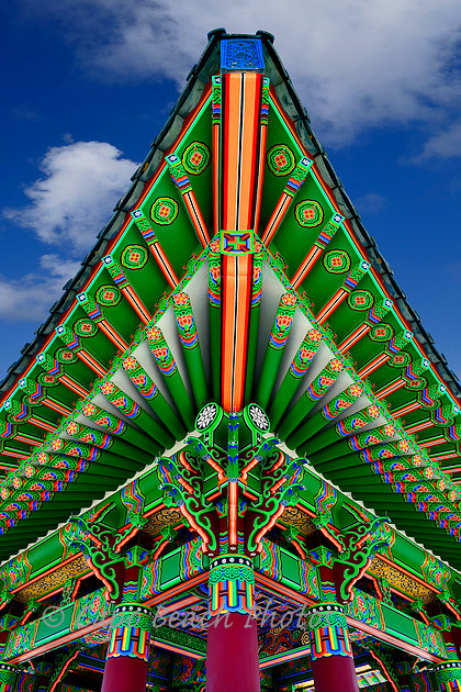
The "Bell of Friendship" became the Los Angeles Historic Cultural Monument No. 187 in 1978 and was presented as a bronze bell of friendship from the Republic of South Korea to the United States during our bicentennial celebration in 1976 and represented the close relationship of the two nations. It is the second largest bell ever cast in Korea, the first being from the year 771. That bell and this bell are among the largest in the world. This photo shows the colorful stone pavilion which houses this suspended cast alloy friendship bell located in the Korean-American Peace Park occupying the upper part of the former Upper Reservation of Fort MacArthur in San Pedro, California. Actor Philip Ahn was instrumental in making the bell a reality at San Pedro. He starred in many movies and television shows including Hawaiian Eye, Perry Mason and Kung Fu. He is the first Asian American to receive a star on the Hollywood Walk of Fame. The bell has a height of 12 feet and a diameter of 7 1/2 feet, the walls of the bell are 8 inches thick. Over 17 tons of copper and tin were used in this alloy casting with gold, nickel, lead, phosphorus added for tonal quality. Since 2010, the bell is struck 6 times a year: New Years Day, Korean American Day, Fourth of July, Korean Liberation Day, Constitution Day in early September and on September 11 to commemorate 9/11. The bell does not have a clapper but is rather hand struck with a suspended swinging wooden mallet. The day I arrived at the monument was one of those picture perfect days in California. No people, yet the sky was bright and blue. I was able to take photos from any angle. The day was so bright that the underside of the pavilion glowed as if portrait lighting had been used. The colors were bright and spectacular, very engaging.
The Pavilion
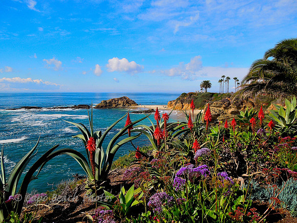
Trailer Park for Lucy and DesiTreasure Island In the 1934 movie "Treasure Island" with Jackie Cooper and Lionel Barrymore, Jim Hawkins (Jackie Cooper) goes on an adventure he will not soon forget. Part of that movie was filmed on the island beyond once known as Treasure Island. Today it is called Goff Island, named after Hubbard Goff who first homesteaded this little bit of paradise in the late 1800's. There was also once a concrete based pier at this beach and a trailer park on the cliffs above. You can still see some remnants of the pier on the beach if you look hard. But you would hardly know that by seeing it now. Since 2003 this gorgeous location has been home for The Montage Resort, a combined beach cottage rental and luxury hotel resort focused on the affluent traveler. However, in 1953 this location was nothing more than an ordinary trailer park, albeit with the best view of southern California beach life. The beach below the trailer park was known as Treasure Island Beach and the island retained its notoriety from the filming of the movie with Jackie Cooper playing Jim Hawkins. The trailer park was also home to Lucille Ball and Desi Arnaz in the filming of MGM Studio's movie "The Long, Long, Trailer". Anyone growing up in the 1950's and 1960's knows Lucy and her real life husband Desi (Ricky in the TV show), the Cuba born band leader. The movie in its own right was a success for the studio and still has a cult following. Though not connected to the actual TV show, the movie was really a full feature version of Lucy and Ricky in Technicolor. Parts of the movie were filmed in Yosemite National Park and here on the cliffs above Treasure Island. During the filming of the movie, two existing palm trees at the real life trailer park Shore Acres were named for Lucy and Desi. These two palm trees still exist today, overlooking the beautiful southern California coastline resort. Of course they have grown a little, towering about 100 feet or so and are located in the front yard of The Studio Restaurant at cliff side over the Treasure Island Beach below. Memories of times past in southern California. . . Red Painted Faces
Red Painted Faces The Paiute Indians were very early inhabitants of the Paunsaugunt Plateau area known as Bryce Canyon, some say as early as the 12th century. The Paiutes called the hoodoos formed at Bryce Canyon the anka-ku-was-a-wits, or "red painted faces". They believed these pinnacles were once The Legend People and their fates became sealed when the mythological character and trickster Coyote turned them to stone for their bad deeds. The hoodoos consist of over 60 known shades of white, yellow, red, purplish and vermilion colored sandstone and limestone eroded over centuries from water and frost. The whimsical arrangement of these hoodoos reminds us perhaps of Gothic spires, steeples, castle walls, fortresses, sentinels or a forest of figurines. First discovered by European Americans in the early 1850's, it wasn't until Mormon pioneer Ebenezer Bryce and a few other families moved to the valley just east of the canyon in 1875 that there was truly any year round settlement of this area. Make-shift bridges and irrigation trenches had to be devised to water crops and feed livestock. Ebenezer Bryce was known for saying that the canyon area was a 'helluva place to lose a cow'. Settlers who came to the area after Bryce called it Bryce's canyon. Road access to Bryce had always been difficult and it wasn't until the Union Pacific Railroad got involved in providing accessible transportation and real roads built that it became more popular for vacationers. The park deserves much of its public notoriety and emergence from obscurity to a national forest supervisor named J.W. Humphrey, who in 1915 after exploring the area, promoted it whole-heartedly to Utah State as well as the National Park Service in Washington, D.C. He developed a series of trails down into the canyon and even led guided tours himself along the system of trails he built. In 1923, President Warren Harding officially established it as a national monument and in 1928 it became Bryce Canyon National Park. Bryce Canyon is a series of amphitheaters, 8 all total,the largest of which is shown in this photo, known as The Bryce Amphitheater. These colors are very realistic. This photo looks northeast from atop the Rim Trail which skirts the eastern edge of the Paunsaugunt Plateau where millennia ago the earth shifted to create these cliffs. This photo was taken from an elevation of 8700 feet in early afternoon with a Nikon D800, 16mm lens set to f/22 at 1/80th shutter speed, ISO250, and polarizing filter. |