|
Bloggin' the Whole Story Thanks to everyone who frequents this website for the photos and blogs. On this blog site there will be a variety of photos and descriptive posts. Some posts involve extensive research, both from talking to locales and supplemented from the internet, while others are posted for the simple photo alone. Please enjoy and don't be afraid to give back your comments, good or bad. Candy Striper
The Candy Striper - The West Quoddy Lighthouse is the easternmost lighthouse in the contiguous U.S. Built on a easterly-pointing peninsula in southeastern Lubec, Maine where it keeps mariners safe while passing through the Quoddy Narrows between Lubec and Campobello Island Canada. A lighthouse was first built here in 1808 but was so poorly built in had to be rebuilt in 1831. The current one is a painted striped brick tower as shown above and was built in 1857. The stripes were painted shortly after it was built. It was automated in 1988. It stands 47 feet tall and the third order fresnel lens is 83 feet above sea level. The light keeps mariners safe as they pass through the Quoddy Narrows that border the U.S. and Canada. The original lighthouse in 1808 was built for $5000, and the lightkeepers yearly salary was a mere $250. Congress had appropriated an amount of $15,000 when it was rebuilt in 1857 and the lightkeepers salary was raised to $450 per year. In 1990 U.S 25 cent postage stamp depicted the lighthouse with only 13 stripes rather than the actual 15 stripes. The only other lighthouse with red and white painted horizontal stripes in the U.S. is on Assateague Island on the eastern coastline of Virginia. The red stripes were common place with Canadian lighthouses because it made the towers stand out against the snow. The color red has the longest visual wavelength so it can be seen the furthest out to sea. The West Quoddy light can be seen about 18 nautical miles out to sea. Salvaged Rusty Ship
Shipwrecked - The Squall Along State Road 166 to Castine, Maine lies the Morse Cove Marina. The small little two lane rural road is a round about way to get to the Dice Head Lighthouse at the entrance to Penobscot Bay. Hardly a highly travelled tourist thoroughfare, the small road is lined with alder and birch trees that easily conceal the entrance to the marina. In a rush to get to the lighthouse, I had time for no other distractions that day, I was on a mission, after all, to photograph another lighthouse. But out of nowhere while traveling down this rural two lane my eye caught a glimpse of a burnt orange object near the water of Penobscot Bay and I knew i had to investigate. The object was undistinguishable from the roadside so I turned into the Morse Cove Marina and parked. I approached the shanty one story wooden office structure and walked inside but no one was there. Stepping back outside I yelled "hello, anyone here. . . " while closing the door behind me. But no answer. It was lunchtime and so it must have been for everyone who worked there. I walked over to the large dry dock hanger on the other side of the sloping concrete boat launch ramp leading to the water. Again, I yelled, "anyone here", but again no answer. So I decided to head down to the water. There was a long narrow elevated wooden dock leading to the rusty ship seemingly stranded by the extreme low tide at the end of the dock. Despite the tide, it was obviously a long term resident of the marina. A definite salvage undertaking not for the faint of heart. Rather than head down to the boat on that precarious wooden dock, I ventured down to the sandy rock beach to photograph the ship from high water eye-level. It was quite an image, stranded by the low tide, set against the bright-blue Maine sky laced with dark gray clouds. When a photographer sees an image like this, ripe for the taking, the shutter must fly. I do not know much about this ship called "The Squall", an obvious salvaged marine vessel that has seen better days. Is there a hope to restore this vessel ? Or is it strictly for salvage metal ? I knew I could not let the opportunity pass me by. It is the same point I have tried to make in previous blogs, such as in Victoria Beach Ledge in March of 2014, http://www.capistranobeachphotography.com/blog/2014/3/victoria-beach-ledge. While looking for the obvious, the unexpected may appear. Turn around and take a minute or two to see what else there is. Lester the Pig
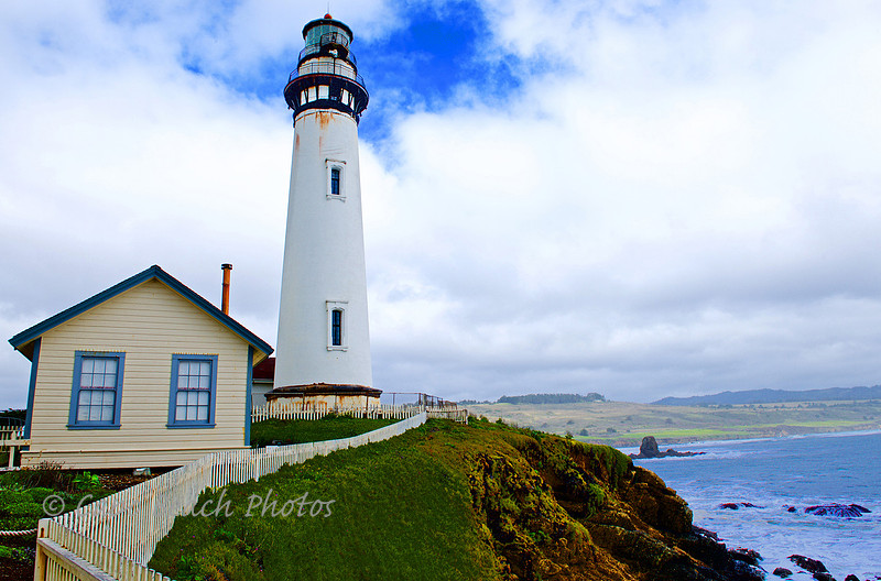
The cargo ship Carrier Pigeon bound for San Francisco from Boston ran aground on the shores of Pigeon Point, just 50 miles south of the Bay area. The ship had painted on its bow a carrier pigeon in flight but it was of no good fortune that day in June 1853. The ship had been built in Bath Maine in 1852 for $54,000. It had taken three months sailing around Cape Horn and was headed to San Francisco with foodstuff and supplies for California's gold rush fever. As thick dense fog lingered for days off the coast, the ships young captain grew impatient and headed in toward shore for safety thinking he was still a safe distance off. The ship fell prey to the projecting promontory outcroppings of the point. Within the hour, hundreds of town folk from nearby Pescadero ran to the seashore to help those on the ship. With the aid of their small row boats, all crew from the ship were saved as were much of the supplies. All for the keeping. . . thought the towns' folk. A few days later the floundering ship sank on the rocks of the point. The captain renamed this protruding rock formation Pigeon Point in honor of his lost ship and the name stuck. Again in the 1860's two merchant ships, the Coya and the Hellespont ran aground several hundred yards off the point but this time the crew and passengers were not so fortunate. Only 37 crew and passengers were saved while all others perished. So outraged were the local towns' people of the government's lack of concern for navigational safety at this coastal point that they petitioned the U.S. Lighthouse Service Board to build a lighthouse at Pigeon Point. Monies totaling $90,000 were appropriated and in 1872 the lighthouse was completed and officially lit. It is among the tallest lighthouses on the west coast, rivaling Point Arena further up the coastline in California and Yaquina Head in Oregon. The lighthouse had actually been finished in 1871 except for the interior spiral stairway fabricated by a firm in San Francisco. Weather and difficulty in erecting the spiral stairway had delayed getting the stairway installed. The first use of fuel was premium lard oil, derived from pigs. The lantern was that of a first order Fresnel lens that had been originally used at the Cape Hatteras Lighthouse in North Carolina. It had been salvaged during the civil war when that lighthouse lantern had been extinguished and removed. The lens came into good use at Pigeon Point. In 1888, the fuel of choice became kerosene, no longer pig oil. Today, the Fresnel lens has been removed and stored in an adjacent museum building. The light is still active by use of an aerobeacon which can be seen in this photo at the top mounted to the exterior railing. The estimated cost to renovate the lighthouse in its current state of disrepair is $11.1 million. Shipwrecks continued at Pigeon Point despite the lighthouse until 1953. In 1974, the Coast Guard automated the Light and soon found that the lighthouse was falling victim to severe vandalism. It was then that they stationed Seaman Albert S. Tucker and his wife to fend off vandals. However, they continued to have intruders until they acquired a pet pig that within a year had grown huge tusks and weighed 800 pounds. His name was Lester, the family pet and he had become the "watchdog" over the Lighthouse. He successfully kept at bay all intruders from that point forward. One day while cleaning and maintaining the lantern room atop the 115 foot high tower that had 147 steps to the top, Seaman Tucker turned around in surprise to see Lester beside him ! Perhaps Lester was expressing his fondness for pig oil no longer being used. . . .wonder how Lester ever got back down ? From the Other Side of the Island
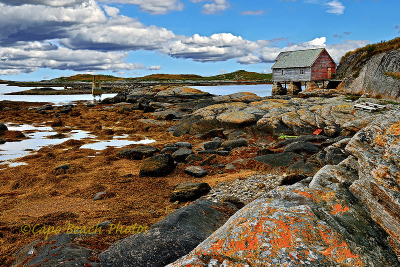
My Favorite Place - I really don't know what it is about this island of Ona in Norway or why this particular spot on the island tugs at me so much, but it is one of my favorite places in the world I think. Two separate islands connected by a small bridge are together referred to as Ona. This old cannery building is located on the southwest side of the larger island of Husøy and it has made it to my blogs before, back in March 2014, but I really want to post it again in case you missed it. This island of Ona has only 40 permanent inhabitants. It was once a thriving fishing community dependent on the abundant fishing grounds so long ago off the Norwegian coastline but now is only a ghost image of its former self. This side of the island is very desolate and requires about a thirty minute walk from the ferry landing. The ferry only arrives twice a day, morning and afternoon. The island is about 24 miles to the west out into the Atlantic Ocean from the mainland. The island also has millennial old remains of a Viking era burial ground from about 852 A.D. This old cannery building has long since been abandoned and continues to show further neglect every time I visit. But it gives me comfort to look on this building while standing on the low tide bedrock surrounded by kelp and tide pools. It is so serene. So apparently permanent yet so obviously temporary. Free from the hustle of any kind of city life, this scene tells me a story of a place where people of the past depended on their fishing livelihood. Resting on man-placed stone piers, rising from the bedrock, makes it feel like it could last a thousand years but with a wooden carcass of a building that has exceeded perhaps its' eighty year life. What contradictions of longevity and the present, surrounded by centuries of historic memories.
Tourist Destination - Laguna Beach
Known world wide as the tourist destination in southern California, the City has always tried to keep this village a low-key casual place to hang out and enjoy the southern California life-style. Countless artists have not only made it home but also a focal point of their artwork, poets have used it as subject matter, while the Beach Boys included it in their ballads. Tourists can shop art galleries, dine, sight-see, beach walk, play beach volleyball, sunbath and surf to mention only a few. Everything here works together toward a general attitude of a laid back beach town. Laguna Beach exists as one of about 18 sand & surf beach town communities stretching from Huntington Beach to San Clemente. After settlement by the early explorers, Laguna Beach was developed and then flourished as an Arts colony at the beginning of the 1900's. The Arts community became formally organized with the formation of the Festival of the Arts and Pageant of the Masters in 1932 which followed the closing of the 1932 Olympic Games in Los Angeles. Accessing this surf town in the early days was by way of the Laguna Canyon Road and further access south to Aliso Canyon was only by way of a dirt road. In 1926, the official Pacific Coast Highway became a paved two lane road from Newport Beach to Dana Point and was dedicated by actors Mary Pickford and Douglas Fairbanks, Jr. in a ribbon cutting ceremony. The Main Beach Park of Laguna Beach, part of which is shown above, was formed in 1968. The City purchased several private properties stretching for about 1000 feet along the beach and razed all the buildings to create the main destination beach and boardwalk tourists enjoy today. The concrete lifeguard tower at the Main Beach Park was moved there in 1937 from across the PCH (Pacific Coast Highway) by a team of horses where it stood as a commercial landmark for the Union Gas Station. Laguna Beach stretches from Newport Beach to the north to Monarch Bay to the south and includes some 20 unique coves and beaches. The town includes some 7 continuous miles of coastline and has a estimated population of 25,300. Some five million tourists visit Laguna Beach each year. Do You Know How to Drive ?
Can You Drive ? When Eugene Coleman and his wife were first reassigned as light keeper's to the Nauset Lighthouse at Eastham, Massachusetts in 1942, neither knew how to drive. After all, they had not needed to, after being light keepers at the Cape Neddick Lighthouse (also known as Nubble Light) in York, Maine for the previous 12 years. Cape Neddick was on an island just slightly offshore near York Maine. When reassigned to the Nauset Lighthouse, they were pleased to be able to socialize with nearby neighbors but sometimes needed to drive. Neither knew how to drive when they first arrived, but they soon learned. The Nauset Lighthouse to where they were assigned was a relocated light tower from Light Station Chatham, about 17 miles to the south down the coastline of Cape Cod. At Chatham there were two twin towers, but the north tower had been shut down in an effort by the Coast Guard to reduce expenses of maintaining two lights. Originally in 1838 at Eastham (Nauset) there were built three lights to nautically distinguish them in between the single light at Highland further north and the two lights at Chatham to the south. The three lights were replacements for previous lights that had eroded away by the ever collapsing cliffs at Nauset Beach. These lights became known as the Three Sisters, because they were about 22 feet tall with white towers and black lanterns making them appear, at least from sea, as if they were women in dresses with top hats. By 1911 with the eroding cliffside, two of these three were taken out of service and sold to locals but the middle one stayed and was moved back. It was renamed The Beacon. But in 1923 it also fell into disrepair due to the eroding cliff and it too was auctioned off. It was replaced with the brick and cast iron light from Chatham. This light had been originally built in Chatham in 1877 and was dismantled in order to be moved to Eastham in 1923. It was placed 200 feet from the cliff edge. But by 1996, the tower was again in danger of collapse. The tower was moved as one piece, across the road, some 800 feet to the west. In 1997 the U.S. Coast Guard decommissioned the tower and transferred it to the National Park Service. It is currently maintained by the Nauset Light Preservation Society. It is estimated that by the year 2070, the tower will again need to be moved. This photograph is taken from inside the doorway of the adjacent oil house. The lighthouse can currently be seen as the logo on a bag of Cape Cod brand potato chips. |