|
Bloggin' the Whole Story Thanks to everyone who frequents this website for the photos and blogs. On this blog site there will be a variety of photos and descriptive posts. Some posts involve extensive research, both from talking to locales and supplemented from the internet, while others are posted for the simple photo alone. Please enjoy and don't be afraid to give back your comments, good or bad. Cape Cod Lighthouse
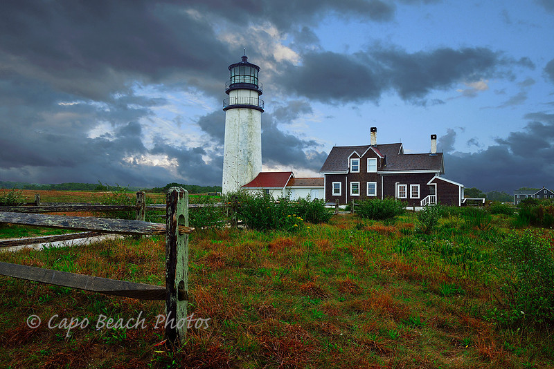
Cape Cod Lighthouse - In 1797 George Washington authorized this Lighthouse be built to warn mariners navigating from Cape Ann down to Nantucket. The original lighthouse was wood and stood until 1832 when it was replaced with a brick version. So badly constructed and in danger of collapse due to beach erosion, it was demolished in 1857. Immediately following the demoliton, the current 66 ft. high tower was constructed and fitted with a first-order Fresnel lens. It is considered the oldest and tallest on Cape Cod. However, in 1996 this current lighthouse was moved back about 450 feet from the cliff edge, again due to severe cliff erosion that was progressing at about 3 feet per year. The light is built on a geological area known as the Clay Pound. It is the highest point anywhere on Cape Cod and therefore led to the name it has as The Highland Light. When the lighthouse was moved in 1996, dual rails were placed from its location at the cliff's edge to its current location. The tower, built of brick was strapped with wood planks and wrapped in steel cables to minimize the jostling of the conical shaped masonry exterior. The structure was pushed in its vertical position ever so slowly up the slight incline to its current location. The day we visited this lighthouse it was extremely windy with 40 mph gusts and torrential rains. The downpour broke clear just long enough to venture out to grab this photograph. The storm was the tail end of Hurricane Matthew that had inflicted damage to the east coast of the U.S. starting in Florida. With so little light available for this mid-afternoon photo and without a tripod at the time, it meant opening the lens to f/9 (any less would have drastically affected the depth of field in this photo) and stabilizing myself for the shutter speed of only 1/40s at ISO 100. I could have increased the ISO setting to say 400 for better light exposure but generally I favor the increased image resolution over faster shutter speed. Isolated Island
Isolated - On the small island of Vikaholmane at the entrance to Skudeneshavn harbor lies this lighthouse or navigational aid called Vikeholmen. The harbor was established in 1849 and the lighthouse built in 1875. It is one of four lighthouses on the larger island of Karmøy just north of Stavanger on the southwest coast of Norway. It is at the northern tip of what is known as the North Sea Road which stretches from Kristiansand to Haugesund. Karmøy is well known in Norway for its sandy beaches, chiseled low lying rock formations and heathered moors. Of the four lighthouses (Høgevarde, Skudenes, Vikeholmen, Geitungen) on this larger island of Karmøy, Vikeholmen is the only one standing isolated at the entrance to the shipping harbor of Skudeneshavn. It was originally established by fishermen of the area and even today is run and maintained by the Seaman's Club of the harbor. Skudeneshavn is a major shipping and ship building port and the lighthouse has always been considered vital to the health and safety of the harbor. The seas around the island of Karmøy is fraught with underlying rocks and turbulent currents. The lighthouse as seen in this photo is not the original, it is an automated navigational aid today located on the same site and can be rented out as a vacation cabin. This lighthouse is one of 24 along the North Sea Road of the southwest coast of Norway. This area has been traditionally one of vital shipping and territorial reign since the early days of the Viking Era, beginning in 752 A.D. The nearby strait of Karmsund which separates the island of Karmøy from the mainland, became the source of the kingdom name "Karmøy" whose first prominent resident was Viking King Harald Fairhair, the first king to have unified Norway under one Kingdom of this name. His Royal Estate was located in Avaldsnes, on the north side of the island. That site is today the largest Viking era archaeological dig in Norway. The placement of lighthouses along this southwest part of Norway stems from the North Sea being such a vital connection between the Baltic Sea and the Atlantic Ocean. Fierce domination for its control has been a source of conflict for moire than a thousand years. During World War II, Germany felt it so important, they tried to fiercely dominate it. This is one major reason so many outposts were established by Germany along the coast of Norway, primarily at lighthouse sites, to make sure Allied forces were not invading and cutting off their naval lifeline to the Atlantic. This photo was strategically taken from the site of a privately catered restaurant across the harbor from the lighthouse. While crews were setting up for the banquet that evening, I took this photo from their outdoor dining area while using a table as my tripod, a Nikon D800 with a 28-300mm telephoto zoom set at 300mm. Lillesand by the Sea
From Poverty to Prosperity and Back Again- The southern coast of Norway, especially along an inner seaway known as Blindleia, is often referred to as the Riviera of Norway. While it is true Norwegians like to spend their holidays, or vacations as we Americans called them, in warmer climates such as Spain, Greece, and Portugal, many Norwegians vacation along the southern coast of Norway. Many have summer cabins and boats, spending every precious warm summer day soaking up the sun with all its inherent activities. This is especially true for such southern coastline towns as Lillesand. Originally called Sanden, or sand beach, back around 1680, it later became known as Lillesand. It was down the road from Kristiansand and needed to be distinguished from it by simply calling it the little or smaller version of a town. It is historically known that the only inn in this area was started by a man named Jakob Justøn Wulff. He is the person most mentioned in connection with the beginnings of this historic ship building and timber shipping sea town. A few kilometers away is a town once called Møglestu, which was once a ruling seat of the Viking age. This town later becomes known as Vestre Moland and forms a larger muncipality with Lillesand in the 1960's. In 1688, Lillesand was granted trading rights which lead to the import of grains and the export of local timber. Prosperity followed but in 1760, the area fell on hard times due to crop failures and local political unrest. A local farmer by the name of Kristian Lofthus formed a protest against the governing officials and ruling towns people. He was incarcerated for this and died in prison a few years later. He had such great influence however for his actions that many historians say he affected the men that later wrote the Norwegian Constitution in 1814. He is considered the most famous man of Lillesand. In the 1800's a man by the name of Steener Steenersen stands out as an engaging entrepreneur that flourished in the timber and ship building industry here. In the years from 1875 to 1895, the ship builders of Lillesand alone were responsible for completing and setting sail to over 50 large wooden sailing ships from this harbor. During this period hundreds of people were drawn to the town and it flourished. But as the wooden ships became obsolete in favor of the steam ships and as the railway took away the shipments of timber, the town became depressed and unemployed. The economy was so bad that emigration, especially to the United States was a necessity to make a living. Others felt a need to free themselves from the state run church and what they felt was religious persecution. As a side note, emigration from Norway to the U.S. from 1825 to 1925 totaled over 800,000. But even more surprising is that from 1825 until 1950 Norway lost over half it's population to the United States, including my parents who emigrated to Seattle in 1950. No other country has contributed a larger percentage of its overall population to America over the years than Norway. It wasn't until the end of World War II, that the local economy of Lillesand began to recover. At present, there are over 14,000 in the greater municipality of Lillesand, and over a 900 people reside in the old town center. Keep in mind the entire current population of Norway is just over 5.2 million. The photo above is the present day harbor of Lillesand that was once such a bustling ship building harbor. As you can see, it now caters to tourists with a Riviera-like atmosphere of shops, waterfront walkway, boating, docks, and marinas. The local church set on the distant hill in the background is entirely wooden and dates back to 1889.
Lindesnes -At the Edge of the World
Lindesnes Lighthouse - On a small headland on Norway's most southern tip is the Lindesnes "Fyr" or lighthouse (in english). This location was first established as a lighthouse in 1655 and is considered by some to be Norway's first lighthouse location. The Norwegian coast has had over 212 lighthouse stations but no more than 156 have been operational at any one time. The word Lindesnes derives from old Nordic languages but in today's definition means "go to the end headlands". And when you're here you can see why it is named that. Standing at this headland you see nothing but out to the west over the Atlantic, no islands or other features to break the view. And it gets windy. It is fairly common to have sustained winds of 60mph. While under Danish rule this site was approved by the Danish King Frederik III to have a light built here to help sailors at sea. It was financed by having sailors pay a tax regardless of their port of entry from Bergen to what is now known as Sweden. The first light was a three story timber tower that used 30 candles behind lead glass windows. The inadequacy of the light so angered sailors dependent on the light that the following year a coal fire lantern was built. Despite this improvement the king closed the lighthouse in 1656. It was not until 1725 that drastic measures were taken to provide a better navigational aid. This was done by merely lighting two open grate coal fires set on the headland rocks and maintained by lightkeepers. In 1854, a brick base with chimney was built with a sheltered lightroom that housed the coal fires. This was used until 1915 when the current 50m tall cast iron tower was built with a first order Fresnel lantern. An adjacent house was built that housed the fog signal and machinery. Originally three families were housed year round at the lighthouse. In 2003 the lighthouse was automated. During WORLD WAR II, the Germans occupied this site as an outpost to view possible Allied naval operations up and down the Norwegian coastline. The Germans suspected the Allies would invade Norway along the coast which never occurred with any great force after the German occupation. (It should be noted that both Allied efforts and Norwegian forces held off the eventual German invasion and occupation for about 62 days, the second longest next to the Soviet Union). After the Germans manned the lighthouse site at Lindesnes, the light was darkened except as needed to aid German shipping. The site had 4 gun posts, all interconnected with tunnels and trenches. Visiting this site at dusk when the tourists had left was ideal. Only a few scattered tourists and the site was open to photograph. It was windy and 11:30 at night. The sun was almost ready to set. Note that even though it was July 5, the sun still sets for a few hours because it is southern Norway not northern. Even with the vibration reduction feature on the 24-70mm f/2.8 Nikkor lens, it still required stabilizing myself against a nearby rock outcrop. The tripod I had was of no use due to it being of a lighter weight for traveling purposes. Singing Sands
It is a rare and eerie phenomena indeed known only in a few sand areas of the world. And the dune areas along the Oregon Coast are one of those areas. The National Dunes Reserve near Florence Oregon has also experienced this weird sensation. Other areas around the world include the Great Sand Desert of Australia, the Gobi Desert of Mongolia and the Empty-Quarter of the Sahara Desert. It is the unique audible sensation known as "singing sand". It is so rare that it is often not commonly discussed because so few have heard it. It occurs under some pretty rare circumstances with different variables in play. The humidity has to be just right. The wind direction and speed also has to be perfect. There are multiple layers and densities of moist and dry sand involved, at least two and sometimes more, with one laying loosely on top of the other. There must also be movement of the sand by wind. The singing sounds are created when by the sand movement, the granules of different sizes and densities become airborne, even if ever so slightly and collide with each other. Again the humidity, wind speed and sand density all play an important and simultaneous interacting role. The choir-like singing sounds have also been likened to distant mythological sirens or violins. There is another type of sound also of a similar phenomena known to be caused by the stirring up of the sand by way of human feet or other body movement such as sliding down a sand dune. This sound can also be a little spooky and is more like a squeaking sound, more common in sandy dune areas. To achieve the singing-type sound, the wind must start slowly. The stirring of the sand by a gentle wind will start this process and if the wind gathers speed and the moisture content of the different layers and types of sand are extreme enough, that choir sound can turn into a musical timbre crescendo that can sound like a ensemble of flutes or trombones playing in harmony. The sound can last for days in different frequencies and has been recorded to cause men to go mad. The Venetian explorer Marco Polo in his travels to China recorded this sound in written documentation some 800 years ago in the Mongolian Gobi Desert. Over the years this sound has been heard in the sand dunes of Cannon Beach, shown here in the photo at sunset. In the earlier parts of this century, the singing sand sound of Cannon Beach was apparently more prevalent and lead several lodging establishments to name themselves "The Singing Sands" to stir business as an added tourist attraction. While most of these businesses have long since gone, a few still exist with that name. Two Rocks Do Not Make A Duckie
Two Rocks Don't Make A Duckie - Iceland, Norway, Greenland, South Africa, Switzerland, Scotland, Australia, the United States are all places where you will find cairns. These are man made stacks of rocks used to mark an important place, a historic place or for way-finding purposes. Cairns have been used since before the time of Christ on earth. Originating from a Scottish gaelic term meaning a type of hill or natural stone pile, the word "cairn" has been used for intentional piles of rocks along sea cliffs, in upland areas, moorlands, mountaintops, burial grounds, and in barren deserts, both the frozen kind and the hot arid kind. Throughout history cairns have been used for a variety of purposes depending on the culture and geographical circumstances. In barren regions such as in the Arctic where few natural outcrops exist, they can be used as structures of identity on an otherwise flat horizon. On mountain trails they have been used to mark the safe passage through an area. In ancient of times they were used as landmarks and as surveying tools. They often located caches of food or other stores in a underground well or pit. Many historic cultures used them for religious reasons where they signified a place where a person or meaningful animal was laid to rest, helping signify its rise up to the heavens and as a place of significant meaning due to that place of death. North American trail markers are sometimes called "duckies" because they often have beaks pointing in the correct direction of travel. The expression "two rocks do not make a duckie" reminds hikers that just having a couple of rocks stacked one on top of the other could be a result of an accident or natural occurrence rather than an intentional trail finding marker. In today's culture these have become known as a way for tourists or visitors to make their mark where they stood or as just a fun thing to do with no other significance. Rocks are often teetered one upon another to show the ingenuity of stacking for perfect balance. It has become such a problem at tourist attractions in Norway that in 2015, the government made it illegal to build such frivolous stacks of rocks in natural settings. Their reasoning was that the stones gathered for these piles have been taken or disturbed from their natural habitat and therefore displacing the natural environment for no distinct purpose. They contend it robs the land of its indigenous setting and can lead to an overabundance of rock piles that cause confusion from genuine navigational aids in the wilderness. This 'Leave No Trace' ethic of outdoor practice advocates for leaving the outdoors undisturbed and in a natural condition with no human footprint. At the Battle of Isandlwana South Africa, in 1879, the British used cairns to mark the mass graves of British soldier's who died in battle. In the Catskill mountains of upper New York State, due to the strong historic Scottish culture, they have been used to mark graves of livestock as well as trail markers. Coastal cairns or sea marks are common found in northern latitudes especially where there may be numerous navigational hazards such as the island strewn waters of Scandinavia and northern Canada. In this photo the small cairn is simple enough and certainly not a danger to anyone. I took the photo just as the cairn was being completed by a woman as the sun set over the Pacific Ocean. Must have been a tourist. . . the exact location is a secret but it was taken along the southern coast of California with an iPhone 6 plus, no flash and at an exposure of 1/1320th @ f/2.2. |